Item (Zoning)
Item Card (XML) | Package Info| ID | 96ea6a368cf64fd08df37afd69044319 |
| Item | https://gis.gastongov.com/publicgis/rest/services/PublicGIS/Zoning/MapServer |
| Item Type | url |
| Owner | gastongis |
| Uploaded | Mar 6, 2023 |
| Modified | Mar 10, 2025 |
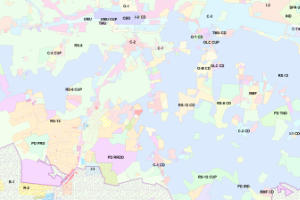
| Thumbnail |
|
| GUID | N/A |
| Name | N/A |
| Title | Zoning |
| Type | Map Service |
| Type Keywords | ArcGIS Server, Data, Map Service, Metadata, Service |
| Description | Zoning for Belmont, Bessemer City, Cherryville, Cramerton, Dallas, Gaston County, Gastonia, Kings Mountain, Lowell, McAdenville, and Stanley |
| Tags | Gaston, UDO, LUC, LDC, Land Development Code, Zoning, Land Use Code |
| Snippet | Zoning for Gaston County area |
| Extent | [-81.4569326997373, 35.1407325598693] - [-80.918046421618, 35.4315942417381] |
| Spatial Reference | NAD_1983_StatePlane_North_Carolina_FIPS_3200_Feet |
| Access Information | Building & Development Services Physical Address: Gaston County Administrative Building 128 West Main Avenue Gastonia, North Carolina 28052 Mailing Address: Gaston County Building & Development Services PO Box 1578 Gastonia, North Carolina 28053-1578 planninggis@gastongov.com 704-866-3195 |
| License Information | The data provided by Gaston County is made available on the condition that the user willingly agrees to waive any and all claims against Gaston County, its contractors, and/or its employees. By accessing this data you are releasing Gaston County, its contractors, and its employees from all liability that may occur from any omissions, errors, or inaccuracies in the data. Any maps, reports, or publications created using the digital data provided by Gaston County shall give credit to Gaston County by using the following statement/disclaimer: “This (map/report/publication) was created using various GIS Data sources, including Gaston County’s GIS data.” This data MAY NOT be resold, or otherwise used for trade or commercial purposes, as defined by NCGS 132-10. (https://www.ncleg.net/EnactedLegislation/Statutes/HTML/BySection/Chapter_132/GS_132-10.html) |
| Culture | en-us |
| Properties | N/A |
| Advanced Settings | N/A |
| Url | https://gis.gastongov.com/publicgis/rest/services/PublicGIS/Zoning/MapServer |
| Proxy Filter | N/A |
| Last Modified | N/A |
| Size | 77 |
| Documentation | N/A |
| App Categories | N/A |
| Industries | N/A |
| Languages | N/A |
| Listed | false |
| Comments Enabled | false |
| # Comments | 0 |
| # Ratings | 0 |
| Avg. Rating | 0.0 |
| # Views | 7020760 |
| Categories | |
| Content Status |
Child Resources: Rating Groups Item Data as Zip Item Dependencies
Supported Operations: Add Rating Delete Rating Related Items Share Item Unshare Item Package Item Set Item Content Status