Item (GastonCountyBoundary)
Item Card (XML) | Package Info| ID | 6f56408344c840edbb95654ffb127407 |
| Item | https://gis.gastongov.com/publicgis/rest/services/PublicGIS/GastonCountyBoundary/MapServer |
| Item Type | url |
| Owner | gastongis |
| Uploaded | Aug 1, 2023 |
| Modified | Feb 12, 2025 |
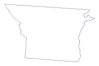
| Thumbnail |
|
| GUID | N/A |
| Name | N/A |
| Title | GastonCountyBoundary |
| Type | Map Service |
| Type Keywords | ArcGIS Server, Data, Map Service, Metadata, Service |
| Description | This data is a compilation of data provided for the surveyed and adopted boundaries between Gaston and Cleveland County, Gaston and Lincoln County, Gaston NC and York SC and Gaston and Mecklenburg County. The Gaston/Cleveland Boundary and Gaston/Lincoln Boundary is from an updated survey in 2007 where the original points were mapped from the1963 County Boundary Survey; the Gaston Lincoln Boundary has been incorporated from the Gaston-Cleveland County Line surveyed by Foresite Engineering. The Gaston/York Boundary is from the NC/SC Boundary Survey that was completed 2017 The Gaston/Mecklenburg Boundary has been incorporated from the Boundary data compiled by the NC Geodectic Survey Official Boundary Map data download only for the Mecklenburg/Gaston Line along the River Boundary. https://ncgs.state.nc.us/pages/County-and-State-Boundaries.htm Updated on April 18, 2020 |
| Tags | Gaston County, Gaston Boundary, Gaston Line, Jurisdiction, Boundaries |
| Snippet | To depict the currently approved county boundary of Gaston County and the extent of service layers within the County. |
| Extent | [-81.4553234366949, 35.1407631489701] - [-80.918046421618, 35.4284815577744] |
| Spatial Reference | NAD_1983_StatePlane_North_Carolina_FIPS_3200_Feet |
| Access Information | Gaston County PO Box 1578 Gastonia, NC 28056 |
| License Information | In acceptance of this digital information it is understood Gaston County does not guarantee that the data and map services will be available to users without interruption Furthermore, Gaston County may modify or remove map services and access methods at will. Any maps, reports, or publications created using the digital data provided by Gaston County shall give credit to Gaston County by using the following statement/disclaimer: “This (map/report/publication) was created using various GIS Data sources, including Gaston County’s GIS data.” This data MAY NOT be resold, or otherwise used for trade or commercial purposes, as defined by NCGS 132-10. (https://www.ncleg.net/EnactedLegislation/Statutes/HTML/BySection/Chapter_132/GS_132-10.html) |
| Culture | en-us |
| Properties | N/A |
| Advanced Settings | N/A |
| Url | https://gis.gastongov.com/publicgis/rest/services/PublicGIS/GastonCountyBoundary/MapServer |
| Proxy Filter | N/A |
| Last Modified | N/A |
| Size | 90 |
| Documentation | N/A |
| App Categories | N/A |
| Industries | N/A |
| Languages | N/A |
| Listed | false |
| Comments Enabled | false |
| # Comments | 0 |
| # Ratings | 0 |
| Avg. Rating | 0.0 |
| # Views | 2509 |
| Categories | |
| Content Status |
Child Resources: Rating Groups Item Data as Zip Item Dependencies
Supported Operations: Add Rating Delete Rating Related Items Share Item Unshare Item Package Item Set Item Content Status